Citation:
Citation_Information:
Originator:
Pacific Islands Benthic Habitat Mapping Center (PIBHMC), Coral Reef Ecosystem Division (CRED), Pacific Islands Fisheries Science Center (PIFSC), National Marine Fisheries Service (NMFS), National Oceanic and Atmospheric Administration (NOAA)
Publication_Date: 20100901
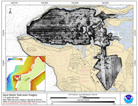
Title: Side-scan imagery of Apra Harbor, Guam U.S. Territory
Geospatial_Data_Presentation_Form: digital data
Online_Linkage: http://www.soest.hawaii.edu/pibhmc
Online_Linkage:
Description:
Abstract:
Gridded side-scan imagery collected in Apra Harbor, Guam U.S. Territory, USA. The GeoTIFF and
Arc ASCII file includes data that were collected using a Klein 3000 high-resolution side-scan sonar system
with dual operating frequencies of 100 and 500 kHz. The data were collected in 2008 by the NOAA Office
of Coast Survey and the United States Navy Fleet Survey Team and were preliminarily processed by NOAA
OCS using the Caris software. Additional processing and mosaicking was performed by the NOAA Coral Reef
Ecosystem Division.
Purpose:
The GeoTIFF and Arc ASCII of side-scan imagery were created using data gathered from multibeam
soundings for use as a planning and reference document. The data are also being used
for benthic habitat mapping, for locating Essential Fish Habitat, and for studying
geologic features of the area. Refer to the supplemental information for instrument
and survey information.
Supplemental_Information:
Survey data were acquired by the United States Navy (USN) Fleet
Survey Team (FST) with Survey Vessel Swamp Fox. The Klein 3000
Side Scan Sonar is operated in the stern-towed configuration.
Additional detailed information on data acquisition, equipment
configuration, and corrections can be found in the Data Acquisition
and Processing Report (DAPR) that can be accessed at: www.soest.hawaii.edu/pibhmc
and is included in the ZIP file containing the side-scan GeoTIFF.
Time_Period_of_Content:
Time_Period_Information:
Range_of_Dates/Times:
Beginning_Date: 20080329
Ending_Date: 20080504
Currentness_Reference: ground condition
Status:
Progress: Complete
Maintenance_and_Update_Frequency: As needed
Spatial_Domain:
Bounding_Coordinates:
West_Bounding_Coordinate: 144.623
East_Bounding_Coordinate: 144.676
North_Bounding_Coordinate: 13.464
South_Bounding_Coordinate: 13.418
Keywords:
Theme:
Theme_Keyword_Thesaurus: NCEI Geoportal Filter
Theme_Keyword: CoRIS_Metadata
Theme:
Theme_Keyword_Thesaurus: CRCP Project
Theme_Keyword:
Benthic Habitat Mapping and Characterization - Commonwealth of the Northern Mariana Islands and Guam
Theme_Keyword: 1398
Theme:
Theme_Keyword_Thesaurus: ISO 19115 Topic Category
Theme_Keyword: imageryBaseMapsEarthCover
Theme_Keyword: 010
Theme:
Theme_Keyword_Thesaurus: CoRIS Theme Thesaurus
Theme_Keyword:
EARTH SCIENCE > Oceans > Bathymetry/Seafloor Topography > Backscatter
Theme:
Theme_Keyword_Thesaurus: CoRIS Discovery Thesaurus
Theme_Keyword: Geographic Information > Backscatter
Theme:
Theme_Keyword_Thesaurus: None
Theme_Keyword: Acoustic Imagery
Theme_Keyword: Side Scan
Place:
Place_Keyword_Thesaurus: None
Place_Keyword: UTM Zone 55
Place_Keyword: Apra Harbor
Place_Keyword: Guam Island
Place_Keyword: U.S. Territory
Place_Keyword: United States of America
Place:
Place_Keyword_Thesaurus: CoRIS Place Thesaurus
Place_Keyword:
OCEAN BASIN > Pacific Ocean > Western Pacific Ocean > Guam > Apra Harbour (13N144E0051)
Place_Keyword:
COUNTRY/TERRITORY > United States of America > Guam > Apra Harbour (13N144E0051)
Place:
Place_Keyword_Thesaurus: CoRIS Region
Place_Keyword: Guam
Access_Constraints: None
Use_Constraints:
These data are not to be used for navigation purposes.
Please acknowledge NOAA (Office of Ocean Exploration and the
Pacific Islands Fisheries Science Center) and the Joint Institute for
Marine and Atmospheric Research (JIMAR) University of Hawaii, the NOAA
Office of Coast Survey, and the USN Fleet Survey Team as the
sources of this information.
Point_of_Contact:
Contact_Information:
Contact_Organization_Primary:
Contact_Organization:
Pacific Islands Benthic Habitat Mapping Center (PIBHMC), Coral Reef Ecosystem Division (CRED), Pacific Islands Fisheries Science Center (PIFSC), National Marine Fisheries Service (NMFS), National Oceanic and Atmospheric Administration (NOAA)
Contact_Address:
Address_Type: mailing and physical address
Address: NOAA IRC
Address: NMFS/PIFSC/CRED
Address: 1845 WASP Blvd., Building 176
City: Honolulu
State_or_Province: HI
Postal_Code: 96818
Contact_Voice_Telephone: 808 725-5360
Contact_Facsimile_Telephone: 808 725-5429
Contact_Electronic_Mail_Address: nmfs.pic.credinfo@noaa.gov
Contact_Instructions: e-mail preferred
Browse_Graphic:
Browse_Graphic_File_Name:
Browse_Graphic_File_Description: Side Scan/Acoustic Imagery
Browse_Graphic_File_Type: JPG
Data_Set_Credit:
Benthic Habitat Mapping Group, Coral Reef Ecosystem Division
(CRED), Pacific Islands Fisheries Science Center (PIFSC), NOAA and the Joint
Institute for Marine and Atmospheric Research (JIMAR) are the sources of
this information.
Security_Information:
Security_Classification_System: Not applicable
Security_Classification: Unclassified
Security_Handling_Description: Not applicable