Online Links:
Benthic Habitat Mapping Group, Coral Reef Ecosystem Division (CRED), Pacific Islands Fisheries Science Center (PIFSC), NOAA and the Joint Institute for Marine and Atmospheric Research (JIMAR) are the sources of this information.
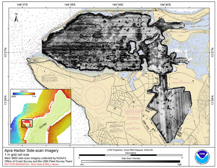
The GeoTIFF and Arc ASCII of side-scan imagery were created using data gathered from multibeam soundings for use as a planning and reference document. The data are also being used for benthic habitat mapping, for locating Essential Fish Habitat, and for studying geologic features of the area. Refer to the supplemental information for instrument and survey information.
Caris HIPS/SIPS (Hydrographic Information Processing System/ Side-scan Information Processing System) is used for processing, correcting, and analyzing all bathymetric, side scan, and phase-differencing bathymetric sonar data. Caris SIPS is used for converting and correcting side-scan sonar imagery and for contact selection and mosaic generation. After acquisition, SSS data are converted from XTF format to Caris HDCS format. Fish height, vessel heading (gyro), and vessel navigation records are then reviewed and corrected and recalculated. Data are then slant-range corrected to 0.1m with beam pattern correction. Side scan mosaics were created using the SIPS side scan editor. Mosaics consisted of combinations of lines that resulted in a seamless product after interpolation was applied during GeoBAR creation in Caris SIPS. Since the dataset is so large, a final mosaic was created using ArcGIS 9.x Raster Dataset Tools in the Toolbox. See the SWAMPFOX Data Acquisition and Processing Report included in the side-scan data download ZIP file (apra_ss_1m.zip) available from http://www.soest.hawaii.edu/pibhmc.
Are there legal restrictions on access or use of the data?Access_Constraints: None
Use_Constraints:These data are not to be used for navigation purposes. Please acknowledge NOAA (Office of Ocean Exploration and the Pacific Islands Fisheries Science Center) and the Joint Institute for Marine and Atmospheric Research (JIMAR) University of Hawaii, the NOAA Office of Coast Survey, and the USN Fleet Survey Team as the sources of this information.
These data are not to be used for navigational purposes. NOAA makes no warranty regarding these data, expressed or implied, nor does the fact of distribution constitute such a warranty. NOAA cannot assume liability for any damages caused by any errors or omissions in these data, nor as a result of the failure of these data to function on a particular system.
| Data format: | TIFF is a format for storage, transfer, display, and printing of raster images. The TIFF file structure allows both the tag and the image data to be encoded into the same file. GeoTIFF refers to a TIFF file that has geographic data embedded as tags within the TIFF file. The geographic data can be used to position the image in the correct location and geometry on the screen of a geographic information display. Any GIS, CAD, Image Processing, Desktop Mapping and other types of systems using geographic images can read any GeoTiff file. More specifically, files of this type can be added to ArcInfo and ArcView 8.x or higher and may be viewed in the Table of Contents as a new raster layer. Image visualization software that does not use geography as a basis for image placement can view a GeoTIFF image as if there were no geographic information in the TIFF file. For example, GeoTIFF files can be viewed using Windows Picture and Fax viewer.The GeoTIFF format is public domain, non-proprietary. in format GeoTIFF, .tif |
|---|---|
| Network links: |
ftp://ftp.soest.hawaii.edu/pibhmc/website/data/cnmi-guam/backscatter/apra_ss_1m.rar |
| Data format: | The Arc ASCII file, for use in ESRI's (http://www.esri.com) GIS software, can be converted to an Arc Raster Grid using ArcToolbox ASCII to Raster conversion tool. in format Arc ASCII, .asc |
|---|---|
| Network links: |
ftp://ftp.soest.hawaii.edu/pibhmc/website/data/cnmi-guam/backscatter/apra_ss_1m.rar |