Citation:
Citation_Information:
Originator:
Pacific Islands Benthic Habitat Mapping Center (PIBHMC),
Coral Reef Ecosystem Division (CRED), Pacific Islands Fisheries Science Center (PIFSC),
National Marine Fisheries Service (NMFS), National Oceanic and Atmospheric Administration (NOAA)
Publication_Date: 20150901
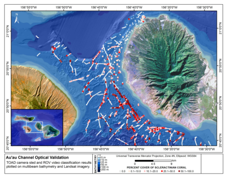
Title:
Map of percent scleractinian coral cover along camera tows and ROV tracks in the Auau Channel, Island of Maui, Hawaii
Geospatial_Data_Presentation_Form: digital image
Online_Linkage:
Online_Linkage: https://www.soest.hawaii.edu/pibhmc/cms/
Description:
Abstract:
This map displays optical validation observation locations and percent coverage of scleractinian coral overlaid on
bathymetry and landsat imagery. Optical data were collected by CRED TOAD camera sled aboard the Hawaiian Islands Humpback
Whale National Marine Sanctuary small boat R/V Kohola cruise SB1505, NOAA small boat R/V AHI cruise MP1401, NOAA ship Hi'ialakai
cruise HA0905 and aboard NOAA ship Oscar Elton Sette cruise SE0807. Data were also collected with Hawaii Undersea Research Laboratory's (HURL) RCV-150
remotely operated vehicle (ROV) on HURL R/V Ka`imikai-o-Kanaloa cruise's KOK0409, KOK0209, and KOK1207.
Purpose:
To display locations of optical validation data in the Auau Channel, Island of Maui, Hawaii, collected by CRED TOAD camera sled and HURL RCV-150
ROV, and the percent coverage of living scleractinian coral along them.
Supplemental_Information:
The Auau Channel, located between the islands of Maui and Lanai and also protected by Molokai to the north, and Kahoolawe
to the south, is bounded by the latitudes 20.983 and 20.733 and the longitudes 156.633 and 156.858. Topography of channel consists of solution basins
and rims (ridges), sediment plains and reef pinnacles on the channel floor, which were subaerially exposed during late Quaternary lowstands of sea level.
Holocene reef growth occurs as a thin veneer on topographic highs in the Channel. The channel reaches depths of 140 m, however the majority of the seafloor
is between 55 m and 70 m deep. The Auau Channel has been documented to include abundant coral reefs at these depths, which are also known as mesophotic coral
ecosystems.
Cruises CoRIS Metadata Record Names
SB1505 cred_toad_mai_sb1505_2015
MP1401 cred_toad_mai_mp1401_2014
HA0905 cred_toad_mai_ha0905_2009
SE0807 cred_toad_mai_se0807_2008
KOK0409 cred_rov_maui_kok0409_2009
KOK0209 cred_rov_maui_kok0209_2009
KOK1207 cred_rov_maui_kok1207_2007
Resource Description: Digital video images that are geo-referenced to navigation files.
Time_Period_of_Content:
Time_Period_Information:
Range_of_Dates/Times:
Beginning_Date: 20071207
Ending_Date: 20150515
Currentness_Reference: ground condition
Status:
Progress: Complete
Maintenance_and_Update_Frequency: As needed
Spatial_Domain:
Bounding_Coordinates:
West_Bounding_Coordinate: -156.8243
East_Bounding_Coordinate: -156.6797
North_Bounding_Coordinate: 20.9371
South_Bounding_Coordinate: 20.7766
Keywords:
Theme:
Theme_Keyword_Thesaurus: NCEI Geoportal Filter
Theme_Keyword: CoRIS_Metadata
Theme:
Theme_Keyword_Thesaurus: CRCP Project
Theme_Keyword:
Benthic Habitat Mapping and Characterization in the Pacific Islands Region
Theme_Keyword: 467
Theme:
Theme_Keyword_Thesaurus: CoRIS Theme Thesaurus
Theme_Keyword: EARTH SCIENCE > Biosphere > Aquatic Habitat > Benthic Habitat
Theme_Keyword:
EARTH SCIENCE > Biosphere > Zoology > Corals > Reef monitoring and assessment > Mapping
Theme:
Theme_Keyword_Thesaurus: CoRIS Discovery Thesaurus
Theme_Keyword: Geographic Information > Habitats
Theme:
Theme_Keyword_Thesaurus: None
Theme_Keyword: Synthesis Map
Theme_Keyword: Mesophotic coral ecosystem
Theme:
Theme_Keyword_Thesaurus: ISO 19115 Topic Category
Theme_Keyword: environment
Theme_Keyword: 007
Place:
Place_Keyword_Thesaurus: CoRIS Place Thesaurus
Place_Keyword:
OCEAN BASIN > Pacific Ocean > Central Pacific Ocean > Hawaiian Islands > Auau Channel > AuAu Channel (20N156W0027)
Place_Keyword:
COUNTRY/TERRITORY > United States of America > Hawaii > Auau Channel > AuAu Channel (20N156W0027)
Place_Keyword:
OCEAN BASIN > Pacific Ocean > Central Pacific Ocean > Hawaiian Islands > Maui Island > Maui Island (20N156W0004)
Place_Keyword:
COUNTRY/TERRITORY > United States of America > Hawaii > Maui > Maui Island (20N156W0004)
Place:
Place_Keyword_Thesaurus: None
Place_Keyword: Main Hawaiian Islands
Place_Keyword: Maui County
Place_Keyword: Auau Channel
Access_Constraints: None
Use_Constraints:
Please acknowledge the NOAA Coral Reef Ecosystem Division, Pacific Islands Fisheries Science Center
as the source of this information.
Point_of_Contact:
Contact_Information:
Contact_Organization_Primary:
Contact_Organization:
Pacific Islands Benthic Habitat Mapping Center (PIBHMC), Coral Reef Ecosystem Division (CRED),
Pacific Islands Fisheries Science Center (PIFSC), NOAA National Marine Fisheries Service (NMFS)
Contact_Address:
Address_Type: mailing and physical
Address: 1845 Wasp Blvd., Bldg. 176
City: Honolulu
State_or_Province: HI
Postal_Code: 96818
Country: USA
Contact_Voice_Telephone: 808-725-5438
Contact_Electronic_Mail_Address: pibhmc@soest.hawaii.edu
Contact_Instructions: e-mail preferred
Browse_Graphic:
Data_Set_Credit:
Benthic Habitat Mapping Group, Coral Reef Ecosystem Division (CRED), Pacific Islands Fisheries Science
Center (PIFSC), NOAA