Citation:
Citation_Information:
Originator:
Pacific Islands Benthic Habitat Mapping Center (PIBHMC), Coral Reef Ecosystem Division (CRED), Pacific Islands Fisheries Science Center (PIFSC), National Marine Fisheries Service (NMFS), National Oceanic and Atmospheric Administration (NOAA)
Publication_Date: 20071230
Title:
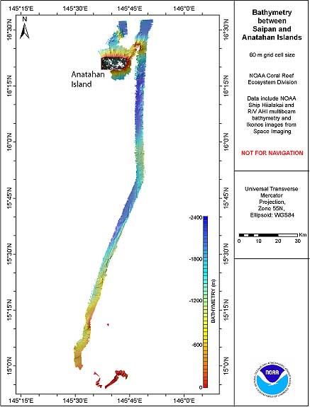
CRED 60m Gridded multibeam bathymetry of seafloor between Saipan
and Anatahan, Commonwealth of the Northern Mariana Islands
(CNMI).
Geospatial_Data_Presentation_Form: digital data
Online_Linkage: http://www.soest.hawaii.edu/pibhmc/pibhmc_cnmi.htm
Description:
Abstract:
Gridded bathymetry shelf, bank and slope environments of
seafloor between Saipan and Anatahan Islands CNMI. Bottom
coverage was achieved in depths between -52 and -2342 meters. The
netCDF and Arc ASCII grids include multibeam bathymetry from the
Simrad EM300 multibeam sonar (30 kHz) collected as of June 2007
by the NOAA Coral Reef Ecosystem Division.
Purpose:
These netCDF and ASCII grids were created using data gathered
from multibeam soundings for use as a planning and reference
document. The data are also being used for benthic habitat
mapping, for locating Essential Fish Habitat, and for studying
geologic features of the area. Refer to supplemental information
for description of instrument and survey.
Supplemental_Information:
Multibeam data were collected aboard the NOAA Ship Hi'ialakai, a
218' United States National Oceanographic and Atmospheric
Administration research ship. The NOAA Ship Hi'ialakai's survey
sensors include a 30 kHz Simrad EM300 sonar and a 300 kHz Simrad
EM3002d sonar, which provide bathymetry and imagery data, a
TSS/Applanix POS/MV Model 320, which measures position, velocity,
attitude and heading, and a Seabird SBE 9/11 plus CTD used to
measure sound velocity profiles.
Specific equipment configurations are documented in metadata from
cruise HI0703. These metadata can be accessed at:
https://www.soest.hawaii.edu/pibhmc/cms/cruise-catalog/
Time_Period_of_Content:
Time_Period_Information:
Range_of_Dates/Times:
Beginning_Date: 20070525
Ending_Date: 20070608
Currentness_Reference: ground condition
Status:
Progress: Complete
Maintenance_and_Update_Frequency: As needed
Spatial_Domain:
Bounding_Coordinates:
West_Bounding_Coordinate: 145.488
East_Bounding_Coordinate: 146.883
North_Bounding_Coordinate: 16.55
South_Bounding_Coordinate: 14.896
Keywords:
Theme:
Theme_Keyword_Thesaurus: NCEI Geoportal Filter
Theme_Keyword: CoRIS_Metadata
Theme:
Theme_Keyword_Thesaurus: CRCP Project
Theme_Keyword:
Benthic Habitat Mapping and Characterization - Commonwealth of the Northern Mariana Islands and Guam
Theme_Keyword: 1398
Theme:
Theme_Keyword_Thesaurus: CoRIS Discovery Thesaurus
Theme_Keyword: Geographic Information > Bathymetry
Theme:
Theme_Keyword_Thesaurus: ISO 19115 Topic Category
Theme_Keyword: elevation
Theme_Keyword: 006
Theme:
Theme_Keyword_Thesaurus: CoRIS Theme Thesaurus
Theme_Keyword:
EARTH SCIENCE > Oceans > Bathymetry/Seafloor Topography > Bathymetry
Theme:
Theme_Keyword_Thesaurus: None
Theme_Keyword: Bathymetry
Theme_Keyword: Multibeam sonar
Place:
Place_Keyword_Thesaurus: None
Place_Keyword: Anatahan Island
Place_Keyword: Saipan Island
Place_Keyword: Commonwealth of the Northern Mariana Islands
Place_Keyword: United States of America
Place:
Place_Keyword_Thesaurus: CoRIS Place Thesaurus
Place_Keyword:
OCEAN BASIN > Pacific Ocean > Western Pacific Ocean > Saipan Island > Saipan Island (15N145E0002)
Place_Keyword:
COUNTRY/TERRITORY > Northern Mariana Islands > Saipan > Saipan Island (15N145E0002)
Place_Keyword:
OCEAN BASIN > Pacific Ocean > Western Pacific Ocean > Anatahan Island > Anatahan Island (16N145E0001)
Place_Keyword:
COUNTRY/TERRITORY > Northern Mariana Islands > Anatahan > Anatahan Island (16N145E0001)
Place:
Place_Keyword_Thesaurus: CoRIS Region
Place_Keyword: CNMI
Access_Constraints: none
Use_Constraints:
These data are not to be used for navigation purposes. Please acknowledge NOAA Pacific Islands Fisheries
Science Center, and the Joint Institute for Marine and
Atmospheric Research (JIMAR) University of Hawaii as the sources
of this information.
Point_of_Contact:
Contact_Information:
Contact_Organization_Primary:
Contact_Organization:
Pacific Islands Benthic Habitat Mapping Center (PIBHMC), Coral Reef Ecosystem Division (CRED), Pacific Islands Fisheries Science Center (PIFSC), National Marine Fisheries Service (NMFS), National Oceanic and Atmospheric Administration (NOAA)
Contact_Address:
Address_Type: mailing and physical address
Address: NOAA IRC
Address: NMFS/PIFSC/CRED
Address: 1845 WASP Blvd., Building 176
City: Honolulu
State_or_Province: HI
Postal_Code: 96818
Contact_Voice_Telephone: 808 725-5360
Contact_Facsimile_Telephone: 808 725-5429
Contact_Electronic_Mail_Address: nmfs.pic.credinfo@noaa.gov
Contact_Instructions: e-mail preferred
Browse_Graphic:
Browse_Graphic_File_Name:
Browse_Graphic_File_Description: Multibeam Bathymetry
Browse_Graphic_File_Type: JPEG
Data_Set_Credit: PIBHMC, CRED, PIFSC, NOAA and JIMAR
Security_Information:
Security_Classification_System: Not applicable
Security_Classification: Unclassified
Security_Handling_Description: Not applicable
Native_Data_Set_Environment:
netCDF file created using the Generic
Mapping Tools (GMT) and ArcGIS ASCII file, both created in a
LINUX environment