Data were also collected aboard the R/V AHI (Acoustic Habitat Investigator), a 25' survey launch owned and operated by the NOAA Pacific Islands Fisheries Science Center in Honolulu, HI. The R/V AHI's survey sensors include a 240 kHz RESON 8101-ER sonar providing bathymetry and imagery data, a TSS/Applanix POS/MV Model 320 which measures position, velocity, attitude and heading, and a Seabird SBE 19 CTD used to measure sound velocity profiles. Sensor configuration for the AHI for cruise AHI-06-02 is documented in the cruise/multibeam metadata file AHI0602_MB_Metadata.txt. Sensor configuration for the AHI for cruise AHI-04-02 is documented in the cruise/multibeam metadata file AHI0402_MB_Metadata.txt. Additional data for the Faga'itua bay area were gathered by the Kongsberg Simrad EM-3000 system, contracted from the Center for Coastal Ocean Mapping of the University of South Florida (USF), and operated from a boat owned by the Department of Marine & Wildlife Resources (DMWR) of the America Samoa Government. For more information please contact: Dawn Wright email:dawn@dusk.geo.orst.edu
Online Links:
Coral Reef Ecosystem Division (CRED), Pacific Islands Fisheries Science Center (PIFSC), NOAA and Pacific Islands Benthic Habitat Mapping Center, School of Ocean and Earth Science and Technology, University of Hawaii
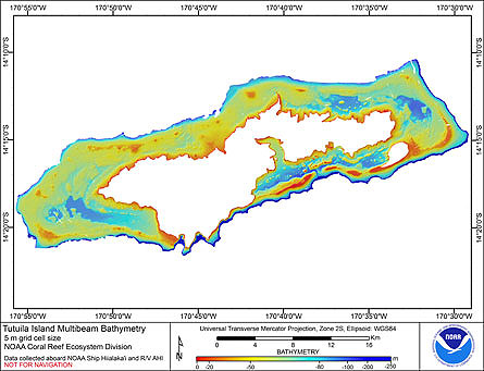
The data were collected in support of Coral Reef Conservation Program goals to map all shallow (0-30 m) coral reefs in US Pacific waters and priority moderate (> 30 m) depth areas by 2009. The data are being used to provide bathymetric and backscatter data for previously unmapped areas; in support of ecosystem management requirements for benthic habitat mapping and location of Essential Fish Habitat; and to study the geologic features of the area.
Are there legal restrictions on access or use of the data?Access_Constraints: None
Use_Constraints:These data are not to be used for navigation purposes. Please acknowledge the NOAA Coral Reef Ecosystem Division, Pacific Islands Fisheries Science Center and the Pacific Islands Benthic Habitat Mapping Center, School of Ocean and Earth Science and Technology, University of Hawaii as the sources of this information.
These data are not to be used for navigational purposes. NOAA makes no warranty regarding these data, expressed or implied, nor does the fact of distribution constitute such a warranty. NOAA cannot assume liability for any damages caused by any errors or omissions in these data, nor as a result of the failure of these data to function on a particular system.
| Data format: | Binary netCDF Grid: This file is formatted as a 2-D binary netCDF grid file. This is the default grid file format used by GMT (Generic Mapping Tools), which created this file. More information can be located at http://gmt.soest.hawaii.edu and http://unidata.ucar.edu/packages/netcdf/index.html and in http://www.ldeo.columbia.edu/res/pi/MB-System/formatdoc/gsf_spec.pdf in format netCDF |
|---|---|
| Network links: |
ftp://ftp.soest.hawaii.edu/pibhmc/website/data/amsamoa/bathymetry/Tutuila_5m.grd.zip |
| Data format: | Arc ASCII can be converted to Arc Raster using ArcToolbox Conversion Tools. in format Arc ASCII |
|---|---|
| Network links: |
ftp://ftp.soest.hawaii.edu/pibhmc/website/data/amsamoa/bathymetry/Tutuila_5m.asc.zip |