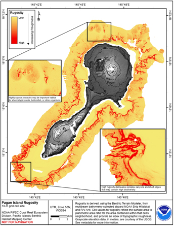
CNMI and Guam rugosity maps are all symbolized with the same stretched color ramp (1.5 standard deviations) in order to provide a standard for qualitative comparisons between islands. Each island has a unique maximum value for rugosity causing the distribution of values across the color ramp to vary slightly. It is recommended that the actual data set be used for integrated analysis in order to make quantitative observations. The values for this data set range from 1.000 to 9.728 with a mean of 1.144 and a standard deviation of 0.275.
The terrestrial elevation data shown in the map for this data set are SRTM Finished 3 arc sec Shaded Relief. They were collected during NASA's Shuttle Radar Topograph Mission (SRTM). For more information on the mission, go to: http://www2.jpl.nasa.gov/srtm/faq.html#data. The data are available from the United States Geological Survey (USGS) as reformatted elevation data that are consistent with other Digital Elevation Models.
Online Links:
NOAA PIFSC CRED and the Pacific Islands Benthic Habitat Mapping Center and JIMAR
The data were derived in support of NOAA Coral Reef Conservation Program goals. Goal 1 is to map all U.S. Coral Reef Ecosystems. This data set specifically addresses Objective 1 and 4: to develop high-resolution benthic maps and to characterize priority deep water reefs and associated habitats. This derivative of bathymetry provides a GIS layer that may be used for benthic and essential fish habitat characterization, and for the study of geologic features. By combining the dataset with bathymetry, backscatter, other derivatives, and in situ data, they collectively compose benthic habitat maps which are designed to be used to understand and predict moderate depth (~20m to 800m) benthic habitats for organisms that inhabit coral reef ecosystems.
Are there legal restrictions on access or use of the data?Access_Constraints: None
Use_Constraints:These data are not to be used for navigation purposes. Please acknowledge NOAA Pacific Islands Fisheries Science Center, and the Joint Institute for Marine and Atmospheric Research (JIMAR) University of Hawaii as the sources of this information.
These data are not to be used for navigational purposes. NOAA makes no warranty regarding these data, expressed or implied, nor does the fact of distribution constitute such a warranty. NOAA cannot assume liability for any damages caused by any errors or omissions in these data, nor as a result of the failure of these data to function on a particular system.
| Data format: | Arc ASCII can be converted to Arc Raster using ArcToolbox Conversion Tools (ASCIItoRaster). in format Arc ASCII |
|---|---|
| Network links: |
https://www.soest.hawaii.edu/pibhmc/cms/data-by-location/cnmi-guam/pagan-island/pagan-island-geomorphology/ |