Online Links:
PIBHMC, CRED, PIFSC, NOAA, and JIMAR
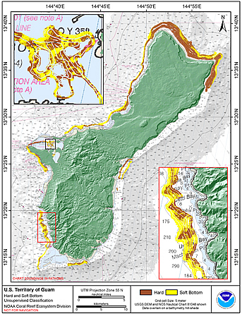
The hard and soft seafloor map is being used to improve sampling techniques for long-term ecosystem monitoring, to guide future ground-truthing operations and to identify coral-rich and species specific environments. This is a preliminary product and the methods used to generate the map are currently being evaluated for their accuracy.
Are there legal restrictions on access or use of the data?Access_Constraints: None
Use_Constraints:These data are not to be used for navigation purposes. Please acknowledge the NOAA Pacific Islands Fisheries Science Center (PIFSC) Coral Reef Ecosystem Division (CRED) and the Pacific Islands Benthic Habitat Mapping Center (PIBHMC), and the Joint Institute for Marine and Atmospheric Research (JIMAR) and School of Ocean and Earth Science and Technology (SOEST), University of Hawaii as the sources of this information.
These data are not to be used for navigational purposes. NOAA makes no warranty regarding these data, expressed or implied, nor does the fact of distribution constitute such a warranty. NOAA cannot assume liability for any damages caused by any errors or omissions in these data, nor as a result of the failure of these data to function on a particular system.
| Data format: | TIFF is a format for storage, transfer, display, and printing of raster images. The TIFF file structure allows both the tag and the image data to be encoded into the same file. GeoTIFF refers to a TIFF file that has geographic data embedded as tags within the TIFF file. The geographic data can be used to position the image in the correct location and geometry on the screen of a geographic information display. Any GIS, CAD, Image Processing, Desktop Mapping and other types of systems using geographic images can read any GeoTiff file. More specifically, files of this type can be added to ArcInfo and ArcView 8.x or higher and may be viewed in the Table of Contents as a new raster layer. Image visualization software that does not use geography as a basis for image placement can view a GeoTIFF image as if there were no geographic information in the TIFF file. For example, GeoTIFF files can be viewed using Windows Picture and Fax viewer. The GeoTIFF format is public domain, non-proprietary. in format GeoTIFF, .tif |
|---|---|
| Network links: |
http://www.soest.hawaii.edu/pibhmc/pibhmc_cnmi_gua_geomorph.htm |