Vertical_Coordinate_System_Definition Depth_System_Definition
Online Links:
NOAA OCS, USN FST, PIBHMC, CRED, PIFSC, NOAA, and JIMAR
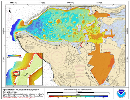
These data were collected in response to a request by the USN for a cooperative modern hydrographic survey with NOAA to provide contemporary hydrographic data to update the nautical charts in the area. The USN plans to use Apra Harbor, Guam as a primary port-of-call. These data will support safe navigation for the USN fleet in Apra Harbor by providing IHO Order 1 hydrography. They will also aid in ongoing habitat mapping efforts by NOAA PIFSC CRED.These netCDF and ASCII grids were created using data gathered from multibeam soundings for use as a planning and reference document. The data are also being used for benthic habitat mapping, for locating Essential Fish Habitat, and for studying geologic features of the area. Refer to supplemental information for description of instrument and survey.
Are there legal restrictions on access or use of the data?Access_Constraints: None
Use_Constraints:These data are not to be used for navigation purposes. Please acknowledge NOAA Pacific Islands Fisheries Science Center, the Joint Institute for Marine and Atmospheric Research (JIMAR) University of Hawaii, the NOAA Office of Coast Survey, and the USN Fleet Survey Team as the sources of this information.
These data are not to be used for navigational purposes. NOAA makes no warranty regarding these data, expressed or implied, nor does the fact of distribution constitute such a warranty. NOAA cannot assume liability for any damages caused by any errors or omissions in these data, nor as a result of the failure of these data to function on a particular system.
| Data format: | These data can be downloaded as either a 2-D binary netCDF raster grid or an ArcGIS ASCII text file. The netCDF grid is the default grid file format used by GMT (Generic Mapping Tools), which created this file. More information can be located at http://www.soest.hawaii.edu/gmt/and https://www.unidata.ucar.edu/software/netcdf/. The Arc ASCII file, for use in ESRI's (http://www.esri.com) GIS software, can be converted to an Arc Raster Grid using ArcToolbox ASCII to Raster conversion tool. in format netCDF |
|---|---|
| Network links: |
ftp://ftp.soest.hawaii.edu/pibhmc/website/data/cnmi-guam/bathymetry/apra_1m_grd.zip |
| Data format: | These data can be downloaded as either a 2-D binary netCDF raster grid or an ArcGIS ASCII text file. The netCDF grid is the default grid file format used by GMT (Generic Mapping Tools), which created this file. More information can be located at http://www.soest.hawaii.edu/gmt/and https://www.unidata.ucar.edu/software/netcdf/. The Arc ASCII file, for use in ESRI's (http://www.esri.com) GIS software, can be converted to an Arc Raster Grid using ArcToolbox ASCII to Raster conversion tool. in format Arc ASCII |
|---|---|
| Network links: |
ftp://ftp.soest.hawaii.edu/pibhmc/website/data/cnmi-guam/bathymetry/apra_1m_asc.zip |