Citation:
Citation_Information:
Originator:
Pacific Islands Benthic Habitat Mapping Center (PIBHMC), Coral Reef Ecosystem Division (CRED), Pacific Islands Fisheries Science Center (PIFSC), National Marine Fisheries Service (NMFS), National Oceanic and Atmospheric Administration (NOAA)
Publication_Date: 20100701
Title:
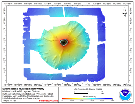
40 m Gridded bathymetry of Swains Island, American Samoa (Arc ASCII format)
Geospatial_Data_Presentation_Form: raster digital data
Online_Linkage: http://www.soest.hawaii.edu/pibhmc
Online_Linkage:
Description:
Abstract:
Gridded bathymetry (40 m cell size) of the slope environment of
Swains Island, American Samoa. Almost complete bottom coverage was achieved
in depths between 7 and 4800 m. The multibeam data are from the Simrad EM300
system aboard the NOAA Ship Hi'ialakai, and the Reson 8101ER system aboard the
R/V AHI and were collected from 10th - 13th February 2006.
Purpose:
The data were collected in support of Coral Reef Conservation Program goals
to map all shallow (0-30 m) coral reefs in US Pacific waters and priority
moderate (> 30 m) depth areas by 2009. The data are being used to provide
bathymetric and backscatter data for previously unmapped areas; in support
of ecosystem management requirements for benthic habitat mapping and
location of Essential Fish Habitat; and to study the geologic features of
the area.
Supplemental_Information:
Data were collected aboard the NOAA Ship Hiialakai, a 218' United States
National Oceanographic and Atmospheric Administration research ship. The NOAA
Ship Hiialakai's survey sensors include a 30 kHz Simrad EM300 sonar
and a 300 kHz Simrad EM3002D sonar, which provide bathymetry and
imagery data, a TSS/Applanix POS/MV Model 320, which measures position,
velocity, attitude and heading, and a Seabird SBE 9/11 plus CTD used to
measure sound velocity profiles. Sensor configuration for the Hi'ialakai for
cruise HI-06-02 is documented in the cruise/multibeam metadata file
HI0602_MB_Metadata.txt.
Data were also collected aboard the R/V AHI (Acoustic Habitat Investigator),
a 25' survey launch owned and operated by the NOAA Pacific Islands
Fisheries Science Center in Honolulu, HI. The R/V AHI's survey sensors
include a 240 kHz RESON 8101-ER sonar providing bathymetry and imagery
data, a TSS/Applanix POS/MV Model 320 which measures position, velocity,
attitude and heading, and a Seabird SBE 19 CTD used to measure sound
velocity profiles. Sensor configuration for the AHI for cruise AHI-06-02
is documented in the cruise/multibeam metadata file AHI0602_MB_Metadata.txt.
Time_Period_of_Content:
Time_Period_Information:
Range_of_Dates/Times:
Beginning_Date: 20040210
Ending_Date: 20060313
Currentness_Reference: ground condition
Status:
Progress: Complete
Maintenance_and_Update_Frequency: As needed
Spatial_Domain:
Bounding_Coordinates:
West_Bounding_Coordinate: -171.218623090848
East_Bounding_Coordinate: -170.938117186678
North_Bounding_Coordinate: -10.935484848778
South_Bounding_Coordinate: -11.188300163771
Keywords:
Theme:
Theme_Keyword_Thesaurus: NCEI Geoportal Filter
Theme_Keyword: CoRIS_Metadata
Theme:
Theme_Keyword_Thesaurus: CRCP Project
Theme_Keyword:
Benthic Habitat Mapping and Characterization - American Samoa and PRIA
Theme_Keyword: 1084
Theme:
Theme_Keyword_Thesaurus: CoRIS Discovery Thesaurus
Theme_Keyword: Geographic Information > Bathymetry
Theme:
Theme_Keyword_Thesaurus: ISO 19115 Topic Category
Theme_Keyword: elevation
Theme_Keyword: 006
Theme:
Theme_Keyword_Thesaurus: CoRIS Theme Thesaurus
Theme_Keyword:
EARTH SCIENCE > Biosphere > Aquatic Habitat > Reef Habitat > Description
Theme_Keyword:
EARTH SCIENCE > Oceans > Bathymetry/Seafloor Topography > Bathymetry
Theme_Keyword:
EARTH SCIENCE > Oceans > Bathymetry/Seafloor Topography > Water Depth
Place:
Place_Keyword_Thesaurus: CoRIS Place Thesaurus
Place_Keyword:
OCEAN BASIN > Pacific Ocean > American Samoa > Swains Atoll (11S171W0001)
Place_Keyword:
COUNTRY/TERRITORY > United States of America > American Samoa > American Samoa > Swains Atoll (11S171W0001)
Place:
Place_Keyword_Thesaurus: CoRIS Region
Place_Keyword: AmSam
Access_Constraints: None
Use_Constraints:
These data are not to be used for navigation purposes.
Please acknowledge the NOAA Coral Reef Ecosystem Division,
Pacific Islands Fisheries Science Center and the Pacific Islands Benthic
Habitat Mapping Center, School of Ocean and Earth Science and Technology, University
of Hawaii as the sources of this information.
Point_of_Contact:
Contact_Information:
Contact_Organization_Primary:
Contact_Organization:
Pacific Islands Benthic Habitat Mapping Center (PIBHMC), Coral Reef Ecosystem Division (CRED), Pacific Islands Fisheries Science Center (PIFSC), National Marine Fisheries Service (NMFS), National Oceanic and Atmospheric Administration (NOAA)
Contact_Person: John Rooney
Contact_Address:
Address_Type: mailing and physical address
Address: NOAA IRC
Address: NMFS/PIFSC/CRED
Address: 1845 WASP Blvd., Building 176
City: Honolulu
State_or_Province: HI
Postal_Code: 96818
Contact_Voice_Telephone: 808 725-5360
Contact_Facsimile_Telephone: 808 725-5429
Contact_Electronic_Mail_Address: nmfs.pic.credinfo@noaa.gov
Contact_Instructions: e-mail preferred
Browse_Graphic:
Browse_Graphic_File_Name:
Browse_Graphic_File_Description: Gridded Bathymetry
Browse_Graphic_File_Type: jpg
Data_Set_Credit:
Benthic Habitat Mapping Group, Coral Reef Ecosystem Division
(CRED), Pacific Islands Fisheries Science Center (PIFSC), NOAA
Security_Information:
Security_Classification_System: Not applicable
Security_Classification: Unclassified
Security_Handling_Description: Not applicable