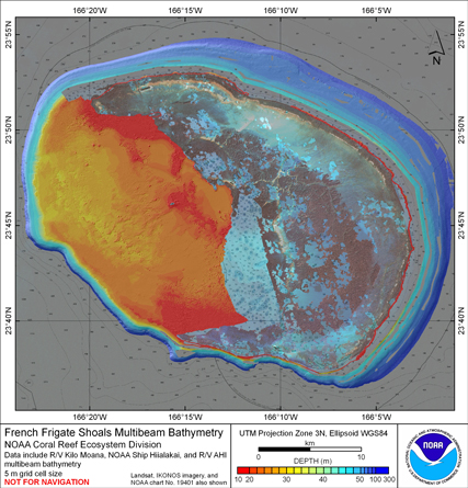
Gridded bathymetry (5m) of the shelf environment of French Frigate
Shoals, Hawaii, USA. The ASCII includes multibeam bathymetry from the Simrad
EM3002d, and Reson 8101 multibeam sonars collected as of June 2008 by the
NOAA Coral Reef Ecosystem Division in depths between 10 and 300 meters.
This ASCII was created using data gathered from multibeam soundings for use as a
planning and reference document. The data are also being used for benthic habitat
mapping, for locating Essential Fish Habitat, and for studying geologic features of
the area. Refer to supplemental information for description of instrument and survey.
Multibeam data were collected aboard the NOAA Ship Hi'ialakai, a 218' United States
National Oceanographic and Atmospheric Administration research ship. The NOAA Ship
Hiialakai's survey sensors include a 30 kHz Simrad EM300 sonar and a 300 kHz Simrad
EM3002d sonar, which provide bathymetry and imagery data, a TSS/Applanix POS/MV
Model 320, which measures position,velocity, attitude and heading, and a Seabird
SBE 9/11 plus CTD used to measure sound velocity profiles.
Multibeam data were also collected aboard the R/V AHI (Acoustic Habitat Investigator),
a 25' survey launch owned and operated by the NOAA Pacific Islands Fisheries
Science Center in Honolulu, HI. The R/V AHI's survey sensors include a 240 kHz
RESON SeaBat 8101-ER sonar providing bathymetry and imagery data, a TSS/Applanix
POS/MV Model 320 which measures position, velocity, attitude and heading, and
a Seabird SBE 19 CTD used to measure sound velocity profiles.
Specific equipment configurations are documented in metadata from cruises HI0501,
AHI0501, HI0503, HI0508, and AHI0508. These metadata can be accessed at:
https://www.soest.hawaii.edu/pibhmc/cms/cruise-catalog/