Citation_Information:
Originator:
Pacific Islands Benthic Habitat Mapping Center (PIBHMC), Coral Reef Ecosystem Division (CRED), Pacific Islands Fisheries Science Center (PIFSC), National Marine Fisheries Service (NMFS), National Oceanic and Atmospheric Administration (NOAA)
Publication_Date: 20070223
Title:
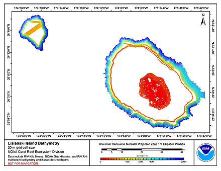
CRED 20 m Gridded bathymetry and IKONOS estimated depths of Lisianski Island, Hawaii, USA (Arc ASCII format)
Geospatial_Data_Presentation_Form: digital data
Online_Linkage:
Abstract:
Gridded bathymetry and IKONOS estimated depths of the shelf and slope environments
of Lisianski Island, Northwestern Hawaiian Islands, Hawaii, USA. Bottom coverage was
achieved in depths between 0 and 5000 meters.The ASCII includes multibeam bathymetry
from the Simrad EM120, EM1002, EM3002d multibeam sonars collected as of October 2006 by
the NOAA Coral Reef Ecosystem Division in depths between 20 and 5000 meters. The ASCII
also includes estimated depths derived from high resolution IKONOS satellite imagery by
the NOAA/NOS/NCCOS/CCMA Remote Sensing Team in shallow water between 0 and 16 meters.
Purpose:
This ASCII was created using data gathered from multibeam soundings and IKONOS
estimated depths for use as a planning and reference document. The data are also
being used for benthic habitat mapping, for locating Essential Fish Habitat, and
for studying geologic features of the area. Refer to supplemental information
for description of instrument and survey.
Supplemental_Information:
Data were collected aboard the R/V Kilo Moana, a 186' United States Navy owned
research vessel. The R/V Kilo Moana's survey sensors include a 12 kHz Simrad EM120
sonar and a 95 kHz Simrad EM1002 sonar, which provide bathymetry and imagery data,
a TSS/Applanix POS/MV Model 320, which measures position, velocity, attitude and
heading, and a Sippican MK-21/PC based XBT system plus a Seabird SBE 9/11 CTD both
of which measured sound velocity profiles.
Multibeam data were collected aboard the NOAA Ship Hi'ialakai, a 218' United
States National Oceanographic and Atmospheric Administration research ship. The
NOAA Ship Hi'ialakai's survey sensors include a 30 kHz Simrad EM300 sonar and a
300 kHz Simrad EM3002d sonar, which provide bathymetry and imagery data, a
TSS/Applanix POS/MV Model 320, which measures position, velocity, attitude and
heading, and a Seabird SBE 9/11 plus CTD used to measure sound velocity profiles.
IKONOS estimated depths were produced using rule-based, semi-automated image analysis of
high-resolution satellite imagery for nine locations in the Northwestern Hawaiian Islands.
For more information about the estimated depth data see the following online link:
http://mercury.ornl.gov/metadata/nbii/html/nos/est%5Fdepth%5Fnwhi.html
Specific equipment configurations are documented in metadata from IKONOS Estimated
Depths and cruises KM0206, HI0507. These metadata can be accessed at:
https://www.soest.hawaii.edu/pibhmc/cms/cruise-catalog/
Theme:
Theme_Keyword_Thesaurus: NCEI Geoportal Filter
Theme_Keyword: CoRIS_Metadata
Theme:
Theme_Keyword_Thesaurus: CRCP PRoject
Theme_Keyword:
Benthic Habitat Mapping and Characterization - Northwestern and Main Hawaiian Islands
Theme_Keyword: 1217
Theme:
Theme_Keyword_Thesaurus: CoRIS Discovery Thesaurus
Theme_Keyword: Geographic Information > Bathymetry
Theme:
Theme_Keyword_Thesaurus: ISO 19115 Topic Category
Theme_Keyword: elevation
Theme_Keyword: 006
Theme:
Theme_Keyword_Thesaurus: CoRIS Theme Thesaurus
Theme_Keyword:
EARTH SCIENCE > Oceans > Bathymetry/Seafloor Topography > Bathymetry
Theme:
Theme_Keyword_Thesaurus: None
Theme_Keyword: Bathymetry
Theme_Keyword: Multibeam sonar
Theme_Keyword: satellite imagery
Theme_Keyword: estimated depth
Place:
Place_Keyword_Thesaurus: None
Place_Keyword: Lisianski Island
Place_Keyword: Hawaii
Place_Keyword: Northwestern Hawaiian Islands
Place_Keyword: United States of America
Place:
Place_Keyword_Thesaurus: CoRIS Region
Place_Keyword: NWHI
Place:
Place_Keyword_Thesaurus: CoRIS Place Thesaurus
Place_Keyword:
COUNTRY/TERRITORY > United States of America > Hawaii > Honolulu > Lisianski Island (25N173W0001)
Place_Keyword:
OCEAN BASIN > Pacific Ocean > Central Pacific Ocean > Northwestern Hawaiian Islands > Lisianski Island (25N173W0001)
These data are not to be used for navigation purposes.
Please acknowledge NOAA and the Joint Institute for Marine and Atmospheric Research (JIMAR)
University of Hawaii as the sources of this information.