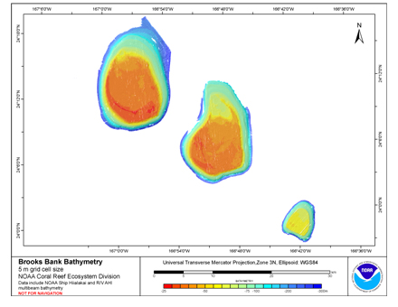
Abstract:
Gridded bathymetry (5m) of the shelf and slope environments of Brooks Banks,
Hawaii, USA. The ASCII includes multibeam bathymetry from the Simrad EM300,
Simrad EM3002d, and Reson 8101-ER multibeam sonars collected as of December 2006
by the NOAA Coral Reef Ecosystem Division in depths between 20 and 300 meters.
Purpose:
This ASCII was created using data gathered from multibeam soundings for use as a
planning and reference document. The data are also being used for benthic habitat
mapping, for locating Essential Fish Habitat, and for studying geologic features of
the area. Refer to supplemental information for description of instrument and survey.
Supplemental_Information:
Multibeam data were collected aboard the NOAA Ship Hi'ialakai, a 218' United States
National Oceanographic and Atmospheric Administration research ship. The NOAA Ship
Hiialakai's survey sensors include a 30 kHz Simrad EM300 sonar and a 300 kHz Simrad
EM3002d sonar, which provide bathymetry and imagery data, a TSS/Applanix POS/MV
Model 320, which measures position,velocity, attitude and heading, and a Seabird
SBE 9/11 plus CTD used to measure sound velocity profiles.
Multibeam data were also collected aboard the R/V AHI (Acoustic Habitat Investigator),
a 25' survey launch owned and operated by the NOAA Pacific Islands Fisheries
Science Center in Honolulu, HI. The R/V AHI's survey sensors include a 240 kHz
RESON 8101-ER sonar providing bathymetry and imagery data, a TSS/Applanix
POS/MV Model 320 which measures position, velocity, attitude and heading, and
a Seabird SBE 19 CTD used to measure sound velocity profiles.
Specific equipment configurations are documented in metadata from
cruises HI0503, HI0612, and AHI0612. These metadata can be accessed at:
https://www.soest.hawaii.edu/pibhmc/cms/cruise-catalog/
Theme:
Theme_Keyword_Thesaurus: NCEI Geoportal Filter
Theme_Keyword: CoRIS_Metadata
Theme:
Theme_Keyword_Thesaurus: CRCP PRoject
Theme_Keyword:
Benthic Habitat Mapping and Characterization - Northwestern and Main Hawaiian Islands
Theme_Keyword: 1217
Theme:
Theme_Keyword_Thesaurus: CoRIS Discovery Thesaurus
Theme_Keyword: Geographic Information > Bathymetry
Theme:
Theme_Keyword_Thesaurus: ISO 19115 Topic Category
Theme_Keyword: elevation
Theme_Keyword: 006
Theme:
Theme_Keyword_Thesaurus: CoRIS Theme Thesaurus
Theme_Keyword:
EARTH SCIENCE > Oceans > Bathymetry/Seafloor Topography > Bathymetry
Theme:
Theme_Keyword_Thesaurus: None
Theme_Keyword: Bathymetry
Theme_Keyword: Multibeam sonar
Place:
Place_Keyword_Thesaurus: None
Place_Keyword: Brooks Banks
Place_Keyword: Hawaii
Place_Keyword: Northwestern Hawaiian Islands
Place_Keyword: United States of America
Place:
Place_Keyword_Thesaurus: CoRIS Place Thesaurus
Place_Keyword:
COUNTRY/TERRITORY > United States of America > Hawaii > Honolulu > Brooks Banks (24N166W0002)
Place_Keyword:
OCEAN BASIN > Pacific Ocean > Central Pacific Ocean > Northwestern Hawaiian Islands > Brooks Banks (24N166W0002)
Place:
Place_Keyword_Thesaurus: CoRIS Region
Place_Keyword: NWHI
These data are not to be used for navigation purposes.
Please acknowledge NOAA and the Joint Institute for Marine and Atmospheric Research (JIMAR)
University of Hawaii as the sources of this information.