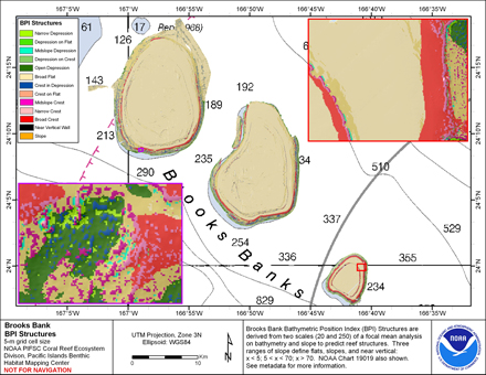
BPI Structures are derived from two scales of a focal mean
analysis on bathymetry and slope. The grid is based on
gridded (5 m cell size) multibeam bathymetry, collected aboard NOAA ship Hi'ialakai
and R/V AHI. It was created using the Benthic
Terrain Modeler (
https://coast.noaa.gov/digitalcoast/tools/btm.html). Cell values
represent one of 13 classes in an index of seafloor terrains. This data set
is for Brooks Banks, Hawaii, USA.
The data were derived in support of Coral Reef Conservation
Program goals. Goal 1 is to map all U.S. Coral Reef Ecosystems.
This data set specifically addresses Objective 1 and 4: to develop
high-resolution benthic maps and to characterize priority deep
water reefs and associated habitats. This derivative of
bathymetry provides a GIS layer that may be used for benthic and
essential fish habitat characterization, and for the study of
geologic features. By combining the dataset with bathymetry,
backscatter, other derivatives, and in situ data, they
collectively compose benthic habitat maps which are designed to
be used to understand and predict moderate depth (~-20m to -150m)
benthic habitats for different organisms that inhabit coral
reef ecosystems.
Multibeam data were collected aboard the NOAA Ship Hi'ialakai, a 218' United States
National Oceanographic and Atmospheric Administration research ship. The NOAA Ship
Hiialakai's survey sensors include a 30 kHz Simrad EM300 sonar and a 300 kHz Simrad
EM3002d sonar, which provide bathymetry and imagery data, a TSS/Applanix POS/MV
Model 320, which measures position,velocity, attitude and heading, and a Seabird
SBE 9/11 plus CTD used to measure sound velocity profiles.
Multibeam data were also collected aboard the R/V AHI (Acoustic Habitat Investigator),
a 25' survey launch owned and operated by the NOAA Pacific Islands Fisheries
Science Center in Honolulu, HI. The R/V AHI's survey sensors include a 240 kHz
RESON 8101-ER sonar providing bathymetry and imagery data, a TSS/Applanix
POS/MV Model 320 which measures position, velocity, attitude and heading, and
a Seabird SBE 19 CTD used to measure sound velocity profiles.
The metadata for the bathymetry is documented in
the product metadata, brooks_5m.asc.
References:
Lundblad et al., 2006, A benthic terrain classification scheme for
American Samoa, Marine Geodesy, 29(2):89 - 111.
https://coast.noaa.gov/digitalcoast/tools/btm.html